When investing in active transportation, it’s important to know where people are walking and cycling. It’s also critical to understand where people could be walking and cycling if new infrastructure prompts them to change how they travel short distances.
When Alta Planning + Design helps public agencies plan for active transportation and safe streets, they turn to Replica data to identify where investments are likely to have the greatest impact. Their Civic Analytics team works with transportation professionals across the USA and Canada to help communities use data to inform how investments in human-scaled transportation can help advance multifaceted community goals.
In three recent projects, Alta leveraged Replica’s mobility and land use data to help clients understand existing conditions and identify next steps for investing effectively in active transportation.
With Replica, Alta is able to:
- Obtain granular, disaggregated data about modeled walking, cycling, and other mobility activity in an area of interest
- Identify trips that have the potential to become walking and cycling trips based on distance, mode, land use, demographics, and origin-destination data
- Seamlessly integrate data into internal GIS tools and interactive applications that help public-sector clients make the most informed decisions possible
Here are three ways the firm leverages Replica data to assist in active transportation planning.
Prioritizing Pedestrian Safety Projects
As part of implementing MnDOT’s Statewide Pedestrian System Plan, Alta is analyzing about 2,000 half-mile-wide areas across Minnesota that the state considers to be high priority for pedestrian improvements. Replica’s data on land uses and trips allowed Alta to develop an understanding of what mobility activity looks like on a typical day in these areas.
Detailed trip data made it possible to identify places where high percentages of short trips (under 1 mile) were made by people driving alone.
“With Replica trip data as our base, we were able to develop robust typologies to inform prioritization based on land use mix and modeled travel behavior characteristics,” says David Wasserman, Alta’s Data Science Practice Leader.

Land use data brought another dimension to the analysis. With Replica’s land use data, Alta could align its analysis with MnDOT’s established land use classifications, making it possible to make specific recommendations that are appropriate for each location.
“Combining the trip and land use data, we’re able to see that people are walking in rural areas, challenging assumptions about where the needs are for pedestrian infrastructure,” lead project planner Maria Wardoku says.
Forecasting the Potential for New Bike and Pedestrian Infrastructure
Decision-making for an active transportation plan in Sumner County, Tennessee, was improved when Alta leveraged Replica data. Replica data combined with a latent demand analysis previously developed by the Greater Nashville Regional Council illustrated the potential demand for new bike lanes and shared-use paths.
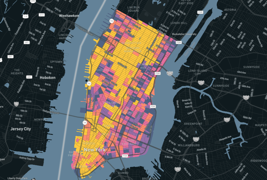
Alta used Replica to identify where trips shorter than 3 miles happen in the county on a typical day, regardless of the mode of travel. The origin and destination points of those trips were then integrated into Alta’s own tools to give Sumner County officials an online map showing the flows of traffic for those short trips.
The map, pictured above and available at this link, informed stakeholder discussions about where to place new paths and bike lanes based on their potential to attract trips that are and aren’t taken by foot or bike today.
Identifying Areas for New Investments
For the Fargo-Moorhead Metropolitan Area in North Dakota and Minnesota, Alta used a similar process to produce a list of priority investment areas for cycling and walking.
With Replica data, Alta developed an interactive map that shows the origins and destinations of bicycling and walking trips, as well as trips less than three-miles-long that could conceivably be served by walking, bicycling, or other micromobility options.
This active trip potential analysis was used in tandem with the results of other analyses — covering equity, connectivity, traffic stress, and crash analyses — to produce priority investment areas for bicycling and for walking.
“The priority investment areas are a key component in determining the bicycle and pedestrian needs as we prioritize projects as part of our Fargo-Moorhead Metro Bicycle & Pedestrian Plan Update,” says Dan Farnsworth, a transportation planner with the Fargo-Moorhead Metropolitan Council of Governments.


.jpg)